Kildare is a county in the Irish midlands located in the province of Leinster. It is named after the town of Kildare. County Kildare is partly in the Roman Catholic archdiocese of Dublin, but mainly in the diocese of Kildare and Leighlin. It is in the Church of Ireland diocese of Meath and Kildare.
The county of Kildare is 67.6 km in length and 41.9 km in width, with a total of 169,550 hectares. It is bordered by the counties of Carlow, Laois, Meath, Offaly, Dublin and Wicklow. As an inland county, Kildare is generally flat. Its highest points are the foothills of the Wicklow Mountains, the hills north of Kildare town and those to the west at Kilcock.
The county has three major rivers running through it: the Barrow, the Liffey and the Boyne, which rises at Trinity Well, Carbury. The Grand Canal traverses the county from Lyons in the east to Rathangan and Monasterevin in the west. From Robertstown a branch goes south to Athy, to connect with the Barrow; from Sallins a line goes to Naas and onwards to Corbally harbour. The Royal Canal stretches across the north of the county along the border with Meath and leaves Co. Kildare at Clonard.
The largest bog land area in Ireland, the Bog of Allen, in the north and north west of the county, covers some 20,000 hectares and is a habitat for over 185 plant and animal species. The other distinguishing feature of the county is the plain of the Curragh, which comprises nearly 2,000 hectares. In ancient times it was the training ground of the Fianna and it’s legendary hero Fionn MacCumhaill. The Irish Army’s headquarters and training centre is located at the Curragh Camp. On the southern fringe of the plain stands the ancient royal residence of Dún Ailinne (Knockaulin).
Pollardstown Fen, adjacent to the Curragh, was declared a National Nature Reserve in 1986. It is the largest surviving calcareous fen in Ireland, covering an area of 220 hectares and is recognised as an internationally important ecosystem with unique and endangered plant communities.
Archaeological evidence for the presence of man in the Co. Kildare in Neolithic times has been found, but the most visible traces of early habitation date to the Bronze and Iron Ages. Those include the Broadleas stone circle, various standing stones, ritual sites, hill forts (including the royal site of Dún Ailinne), crannógs and toghers. By 450 A.D. Christianity was established and churches were built by circa 470 A.D. at the traditional seats of power of Naas, Moone and Kilcullen. In the fifth century St. Brigid founded a monastery on the western edge of the Curragh Plain, near a stand of oak trees, on land donated by the King of Leinster. The settlement on the ancient Ridge of Clay (Druim Criaig) flourished and gave a new name, Cill Dara, ‘Church of the Oak,’ to the area.
Co. Kildare’s network of established monastic settlements were attacked continually by the Vikings. The town of Leixlip in north Kildare owed its origins to the Danish invaders and became the most westerly part of the Viking Kingdom of Dublin. Its name is of Scandinavian origin and is derived from the old Norse for ‘Salmon Leap’ – ‘Lax-hlaup.’
In the 1170s the Anglo-Normans, under Strongbow, took control of Co. Kildare. The native Gaelic clans were deprived of their lands and sought refuge in the mountains of Wicklow and the bogs of north-west Kildare, emerging only to launch sporadic attacks on the intruders. The area known as ‘the Pale’ is most closely associated with the Anglo-Norman parts of counties Dublin, Meath, Kildare and Louth and is noticeably visible near Clongowes and Clane. Kildare was established as a county in 1297 and assumed its present borders in 1832 following amendments to remove a number of enclaves and exclaves. One of the great Norman families to settle in Kildare, the Fitzgeralds, or Geraldines, played a major part in the history of both the county and country as a whole.
In the sixteenth century the Tudors increased their power in Co. Kildare, while the Lord Protector, Oliver Cromwell, seized lands and initiated further plantations between 1649-53. The year 1798 saw the outbreak of rebellion in Ireland, inspired by the American War of Independence and the French Revolution. The Rebellion broke out in Co. Kildare on 23/24th May 1798 with attacks on such places as Ballymore-Eustace, Naas, Prosperous and Clane.
One of the leaders of the 1798 Rebellion, a founder of the Society of United Irishmen and the father of Irish Republicanism, Theobald Wolfe Tone, had strong connections with Co. Kildare. His family lived at Blackhall, Clane, and he is buried nearby at Bodenstown cemetery, near Naas. Although the French came to the aid of the Irish, the rebellion failed and Tone committed suicide before he could be executed. Another famous Kildare man and military leader of the rebellion was Lord Edward Fitzgerald, the son of the Duke of Leinster. He was mortally wounded while resisting arrest in June 1798.
The seventeenth and eighteenth centuries saw the erection of many of Co. Kildare’s great houses, most notably at Castletown and Carton. The building of the Grand Canal began in 1756, and the Royal Canal in 1789, improving the means for the transportation of goods from Dublin and throughout the county. Despite its relative prosperity, Co. Kildare did not escape the Great Famine of 1845-1849, though it was spared its worst effects largely due to its relatively low population density. Co. Kildare had an average total of 187 people per square mile of arable land in pre-famine years, the lowest county figure in the country. The population was 99,065 in 1821 and in 1851 it was 95,723.
Military barracks were built on the main Dublin to Cork and Limerick roads: at Naas (1813), Newbridge (1819), the Curragh (1855) and Kildare Town (1901). They are significant for many undertaking genealogical research in Co. Kildare. Often soldiers brought their families with them to their postings and settled permanently, while others married local women, establishing roots in the county where their descendants still live. The preponderance of English, Scottish and Welsh names in Co. Kildare attests to their presence.
In the early part of the twentieth century the Land League, the Gaelic League and the Gaelic Athletic Association gained widespread support in the county. In 1928 Co. Kildare became the first team to win the Sam Maguire trophy for the All Ireland football championship, defeating Co. Cavan 2-6 to 2-5. Co. Kildare had won the All Ireland in 1905, 1919 and 1927.
Following the War of Independence the Anglo-Irish Treaty was signed in December 1921. The subsequent withdrawal of British forces from Ireland had a negative effect on the economy of Co. Kildare that had relied on the military presence in centres like Newbridge and the Curragh. It was not until the 1930s with the establishment of industries like the Irish Ropes, Newbridge Cutlery, and Bord na Mona that the local economy revived. In more recent times Co. Kildare has become home to industrial giants such as Hewlett-Packard, Intel and Pfizer.
Co. Kildare is the centre of the Irish equine industry and is one of the richest counties outside Dublin. Large estates, stud farms and horse racing establishments are obvious features of the county, while farming remains an important enterprise. County Kildare is twinned with Deauville, France, and Lexington, Kentucky, USA, both major centres of the thoroughbred breeding industry.
The county has grown considerably in demographic terms; the population increased from 122,516 in 1991 to 210,312 in 2011. There are more people living in the county now than at any time in its history. Part of this growth is due to its close proximity to Dublin, with towns such as Leixlip and Celbridge serving as dormitory towns. The other main centres of population in the county are Newbridge, Naas, Athy, Monasterevan, Kildare and Maynooth. Places of interest include Kildare Cathedral and Round Tower, the Irish National Stud, the Japanese Gardens and St. Fiachra’s Gardens, Pollardstown Fen, Bodenstown Cemetery, Kilkea Castle, Maynooth College, Ballitore Quaker village, the Bog of Allen, Moone High Cross, Old Kilcullen Round Tower and High Cross, Castletown House, Robertstown village, Straffan Steam Museum, Donadea forest, Lullymore Heritage and Discovery Park, and the Curragh.
Before you begin the task of tracing your Co. Kildare ancestors it is useful to have an overview of the county in the mid-nineteenth century. One of the most valuable sources for the history of County Kildare is Samuel Lewis's ‘Topographical Dictionary of Ireland’s published in 1837. It can serve as a guidebook for Ireland in 1837, providing a snapshot of life before the famine began in 1845. It is a useful source to use during research, and, for those trying to trace their ancestors in Co. Kildare, it can provide an insight into their ancestor's lives and into the locality in which they lived.
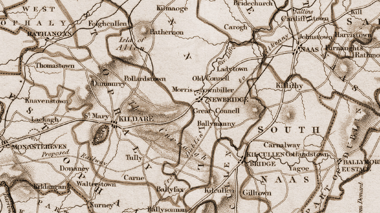
In 2002 the Kildare Collections and Research Service (KCRS) decided to extract all the articles pertaining to Co. Kildare and to re-produce them in one complete searchable document. They are listed in an A-Z format as Lewis had intended. This compliments the original work and offers the researcher quick access to the relevant Co. Kildare information. The original preface (to the two volume 1837 edition) is included, as is the list of Co. Kildare subscribers and the accompanying map of Kildare (from the Atlas which accompanied the 2 vols.). Researchers can access it online at http://kildare.ie/library/lewis-topographical-dictionary/index.asp. The complete two-volume set with maps for the island of Ireland is available via www.askaboutireland.ie
Copyright 2015 - Kiely, Corrigan, Durney